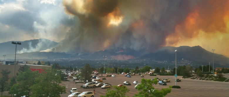
Late in day 4 of the Colorado Waldo Canyon Fire, the Colorado Springs Fire Department Chief Rich Brown said that today, Waldo became a “firestorm of epic proportion.” I liken it to our own Colorado Springs 9-11.
First photo today at 3:00pm…
At 4:00pm from the Chapel Hills Mall, drastically turns perilous…
By 4:50 flames visible, and they were moving fast… right into Mountain Shadows…

4:50pm – From Chapel Hills Mall – Flames now visible and WAY too close to Mountain Shadows & Peregrine
Others who were in Mountain Shadows saw this…
And from north of Colorado Springs near the Air Force Academy…
Back in Mountain Shadows…
Within minutes, smoke smothered all of northwest Colorado Springs…
A few miles east, the Black Forest got smothered, too…

5:40pm – From Black Forest – Smoke had reached BF with less than 1/4 mile visibility by 5:30, cleared by 5:40
Then winds shifted everything back the way it came…

6:05pm – From Black Forest – Winds shifted blowing smoke towards South. True color here, no editing.
Behind the blanket of smoke, Waldo’s insatiable fury and devastation…

From the front lines against Waldo on Rossmere Drive 6/26/12 – h/t @TheWxMeister KRDONews13 Storm Tracker Matt Meister
The mandatory evacuation map. 32,000 residents evacuated.
Video shot from atop Ute Valley Park as the fire burns Mountain Shadows. h/t @DenverPost
And while the fire burns in Mountain Shadows from local @Fox21News…
15,324 acres burned through today and 5% containment.
Onto Wednesday…
——————————
Other Waldo Links
MUST-SEE: KRDO13 Storm Tracker Matt Meister’s 3-D High-Resolution VIDEO of Waldo’s Tuesday eruption into Colorado Springs here.
LISTEN to the Colorado Springs and El Paso County Fire and EMS Scanners online here.
Get the latest incident statistics on the Waldo Canyon Fire at the Incident Information System “InciWeb” here.
Comprehensive community information about donation/volunteer locations, closures, Red Cross shelters, reverse 911 registration and much more at www.SpringsGov.com.
Joint Information Center Phone Numbers: 719-629-7322 720-402-7935 720-202-4510 720-237-9947 720-237-3417
——————————
You never want it to happen to your community.
Yet here it is. Surreal. Heart-breaking.
May God pour His mercy and blessing upon our burning city. May our hearts, eyes, and ears turn to Him. And may God bless and protect our local leadership and firefighters who are bravely fighting this epic beast named Waldo. And please send rain…
——————————-
Michelle Morin is a conservative blogger and speaker for freedom and America’s founding principles. Join her for updates here.


No comments yet.